
Grounding · Spatial agents
Finding and reading traffic signs in street images, and checking the map against them.
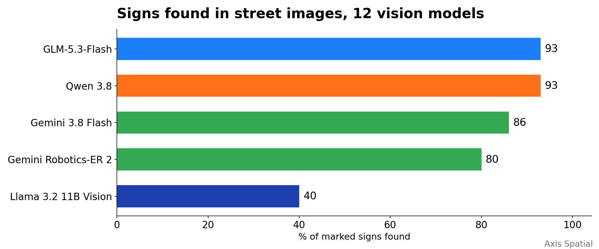
We built a pipeline that finds school-zone speed signs in street-level images, reads the speed and the hours, and checks them against map data and OpenStreetMap schools. On the way we measured which grounding, detection and vision-language models do each step: Grounding DINO found one warning sign in 92.4% of 66 images with the right caption, and GLM-5.3-Flash found 93% of marked signs with one false positive among 12 vision models.
What we built
The task: for each school-zone speed sign in Potsdam and south-west Berlin, say whether it is real, how far the zone runs, and whether the 30 km/h applies all day or only in school hours. We combined sign detections, OpenStreetMap schools, walks along the road graph and street-level images, with a vision model reading each sign crop.
The pipeline passed 63.5% to 69.5% of 315 signs automatically, depending on the version, measured 208 zone extents with a mean length of 168 metres, and found an end sign within 50 metres for 80.3% of them. The rest went to a review queue with the reason attached.
What we measured
- Grounding. Grounding DINO with the caption "red triangle sign . children silhouette sign" found the children warning sign in 92.4% of 66 images; Florence-2's best caption found it in 77.4%. How caption wording changes the result.
- Detection. GLM-5.3-Flash and Qwen 3.8 found 93% of marked signs; Moondream 3.1 found all of them and 22 that were not there. 12 vision models compared.
- Reading. Find, crop and read with Florence-2 read 7 of 7 speed limits; whole-frame reading with Qwen2.5-VL-72B on a shrunk frame read 1. Crops under about 60 pixels were never readable. Why pixels decide it.
- Hallucination. Gemini 2.5 Flash called 150 permanent signs time-limited, and 147 of those answers were the same hours. What fixed it.
- Segmentation and poles. Florence-2 found poles at an F1 of 0.45; SegFormer mixed poles with the signs on them, so we dropped it; masking cars, people and bikes with YOLO took about 70 milliseconds a frame.
Limits
- The image sets are small: 7 to 66 images for most comparisons, 13 hand-marked frames for the 12-model run, about 311 signs for the time-limit run.
- Several reference labels are derived data, not a person checking every sign.
- One region, one country's signs and one time window.
If you need objects found, read or checked in your own street or satellite images, or a map checked against imagery, tell us about the work.
Start here
Want this on your own data?
Send us one task your team does today, the data it uses and the software it runs in. We will tell you which model can do it and what it would take.