For AI labs
Tasks that show where models misread the physical world.
We write private evaluation tasks on real satellite, radar and lidar data, each with a verifier. Labs use them to measure what public benchmarks do not cover.
Key findings
Frontier models know the Earth better than they see it: 95 of 100 on knowledge questions, 59 on reading images. Figures from the Spatial Intelligence Index, 17 November 2026.
- 86
- Geospatial agent work. Best agent on GIS and Earth observation work, in a sandbox with tools.
- 59
- Vision. Best score on questions about satellite and aerial images, with no tools.
- 95
- Geospatial knowledge. Best score on closed-book questions about places, maps and coordinates.
- 48 models
- Scope. From 14 labs, on the same tasks.
On our private sample tasks, weaker models got 0 of 5 attempts right and stronger models 1 of 3, with web search and tools on. They guess the place and skip reading the picture.
The public index shows how the method reads across the major models. Your engagement is the private version: tasks that stay unpublished, built for the gap you name.
Three ways to work with us
- Ready-made task sets. Tasks we have already written and measured models on.
- Custom evaluations. Tasks built for the gap you name.
- Partner benchmark. Built with a lab or an industry partner and published under both names on the index.
Task areas
- Change in satellite imagery. What was built, cleared or flooded between two dates, and how much. Beside DVL-Bench on the index.
- Radar (SAR). Reading Sentinel-1 scenes: slicks, water and structures that optical images miss. Beside InSAR Regional Snow Mapping on the index.
- Lidar and terrain. Earthworks, slopes and volumes from 1 m elevation models. Beside GS-QA2 on the index.
- Monitoring over time. When something started, how fast it grew and when it stopped, from a series of scenes. Beside GeoChrono on the index.
One sample task
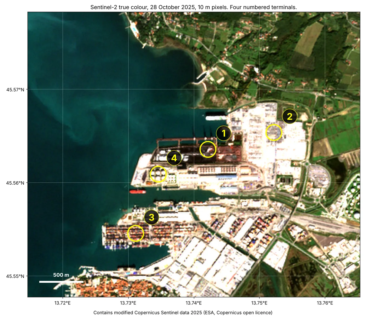
The picture shows a port with four numbered terminals, and only one handles containers. The model must pick it from the pixels, look up its quay length and the port's container traffic in public records, and work out the boxes handled per metre of quay per day.
How it works
- Specify. You name the work and where your model fails.
- Measure. We run current models on private tasks with verifiers and report where each one fails.
- Improve. We write task sets and environments aimed at those failures. Evaluation tasks and any training data are kept separate.
- Re-measure. We run the evaluation again, on tasks the model has not seen.
Start here
See the tasks for yourself.
Tell us the work and where your model fails. We send sample tasks from the areas above.